Dena Trekking Information
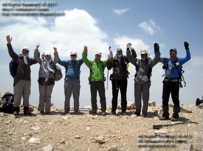
Dena peak is a popular target for hiking & trekking tours in summer season, just like Mount Damavand!
popular target for hiking & trekking tours
In June, July, August and September the mountain is crowded by enthusiastic Iranian mountaineers mainly because Dena is an ideal place for acclimatization and and preparation on Iranian high mountains. Visit also how to Climb Damavand.
Dena Location
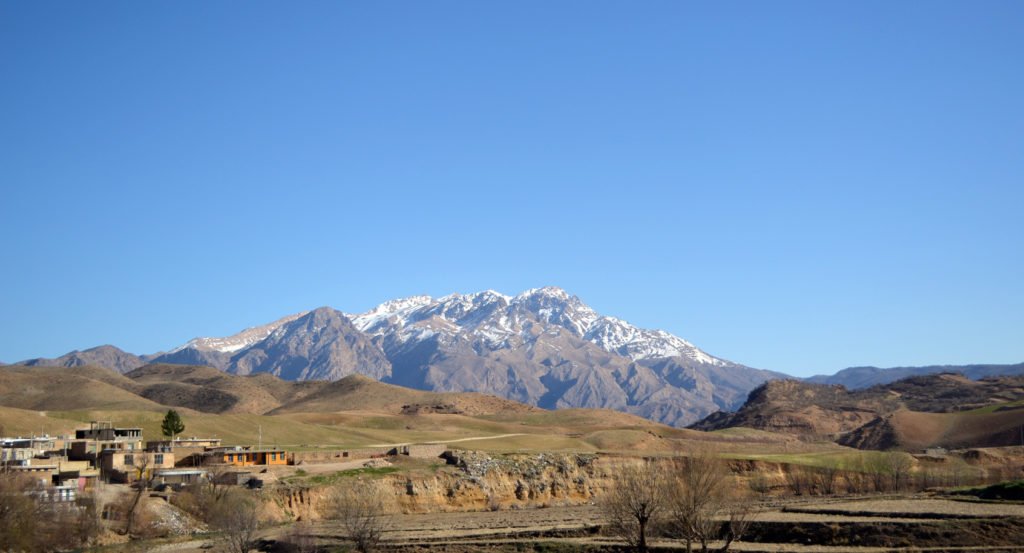
Mt Dena is situated between three Iranian provinces, Isfahan, Kohgiluyeh Boyer-Ahmad and Chaharmahal Bakhtiari. Two major cities closed to this mountain are Semirom in north (Chahar-mahal Bakhtiari Province) and Yasouj city in south (Kohgiloyeh Boyer-Ahmad Province). Geologically, Mount Dena is located in the Sanandaj-Sirjan geologic and structural zone of Iran and is mainly made of Cretaceous limestone.
Sisakht
Sisakht town is the favorite starting point for trekking to Dena summit. This small beautiful city in south west of Iran is the best starting point to many ascents to Dena Peaks from south route. Sisakht city is the second city (after Yasooj) in the southern slop of Mt Dena. Yasooj is the capital of Kohgiluyeh Boyer-Ahmad province. Si-Sakht is in the foothills of Dena Mountain.
Hovzdal (central Hovz Dall, or Dena Peak) 4360 m
Dena South Route
By starting from Sisakht city and hiking through Bozkosh gorge you have access to Sichani (Sichoni) 4200 m, Hovzdal (central Hovz Dall, or Dena Peak) 4360 m. If you intend to spend more time on this part of the mountain, overnight at Cheshme Pouneh Shelter area then visit Hera 4260 m, Bizhan I (Mash) 4340 m and Bizhan II (Borj Asmani, Seh Ghopeh) 4350 m on the same route.
How to go to the Area:
From any direction throughout Iran you can go to the area:
Shiraz city> Ardekan> Yasuj City> Sisakht Town> Sisakht resort/Local house.
Isfahan City> Shahreza> Semirom> Sisakht Town> Sisakht resort/Local house.
Esfahan City> Mobarakeh> Brojen> Sisakht City> Sisakht mountain resort/Local house.
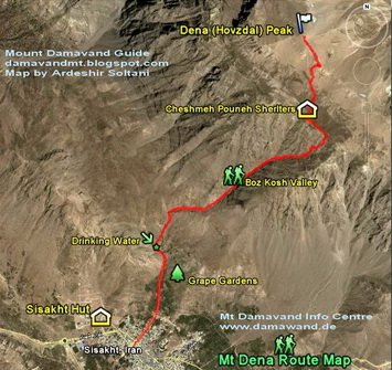
South Route Trekking Map
How to go to Mt Dena:
Sisakht Resort> Boz Kosh Gorge> Cheshme Pouneh Refuge> Dena Peak (Hovz-Dall Summit) 4360 m.
Dena North Route
Bijan III (Qash Mastan) with an elevation of 4,435 meters above sea level, is the highest summit of the Dena Range. For climbing Bizhan 3, the highest peak, you may start from Semirom city and Khafr village in the north face of the mountain.
Alternate names and spellings:
Semirom, Semīrom, Samirum, Sīmrom (in Persian شهر سمیرم – سميرم),
Sisakht Town, Sisakht city, Si-sakht (in Farsi: سی سخت – شهر سی سخت)
Yasouj city, یاسوح – شهر یاسوج
Chahar-mahal Bakhtiari Province, – چهارمحال بختیاری استان چهارمحال بختیاری
Kohgiloyeh Boyer-Ahmad Province, استان کوه گیلویه و بویراحمد – کوه گیلویه و بویراحمد
Facts & Figures
Distances
Trail distance from Sisakht to Cheshme Pouneh Shelter: 6100 meters.
Trail distance from Sisakht to Hovzdal Central Peak: 7800 meters.
South Route Difficulty: Walk up
Best months to climb: June, July, August, September, October,
Convenient starting point: Sisakht, Yasuj
Shelters
3800 Cheshmeh Pouneh (Pedeny Spring) from Tang-e-Bozkosh (Bizhan & Houzdall) – south face
3500 GHash-e-mastan – north face
Famous Peaks
Famous Peaks of Dena Mountain Chain in order of elevation:
– Bizhan III (Ghash Mastan) 4435 m, the highest peak.
– Hovzdal (central Hovz Dall, or Dena Peak) 4360 m
– Bizhan II (Borj Asmani, Seh Ghopeh) 4350 m
– Bizhan I (Mash) 4340 m
– Pazan Pir 4300 m
– Hera 4260 m
– Sichani ( Sichoni) 4200 m
GPS
Mt Dena GPS Landmarks
GPS Landmark, Waypoints for Mount Dena (Central Hovzdal) Peak Iran
Mt Dena Hovzdal Peak
Coordinates
Altitude: 4350 m
Latitude: 30° 54′ 28 N
Longitude: 51°28′ 48 E
Cheshme Pouneh New Shelter
Altitude: 3800 m
Latitude: 30° 53′ 45 N
Longitude: 51°28′ 49 E
Cheshme Pouneh Old Refuge
Altitude: 3800 m
Latitude: 30° 53′ 46 N
Longitude: 51°28′ 50 E
Sisakht Mountain Resort
Coordinates
Altitude: 2300 m
Latitude: 30° 52′ 02 N
Longitude: 51°26′ 52 E
GPS Track and Maps
Downloads
Mt Dena Rout Map full size image: Download
Mt Dena GPS Track: Download
Related Tags
Dena peak, dena summit, dena chain
Dena mountain range, Dena mountains, Dena mountain chain
Dena tour, hiking Dena mountains, trek dana, dena mountain
Trek damavand, hike damavand, damavand tour, Damavand
Trek Dena mountain, hike Dena peak, climb Dena summit
Dena mountains tour, Dena mountain range
Dena Trekking Info MDFR19MAR07B

Trackbacks/Pingbacks